

Drop your spreadsheet in.
Clean, usable addresses come out.
Geocode, enrich and map spreadsheets. Large files welcome. No code required.
Forward Geocoding
Turn addresses into latitude/longitude coordinates.
Reverse Geocoding
Turn latitude/longitude coordinates into approximate addresses.
Data Enrichment
Append additional fields to your results (i.e. Census geographies, Congressional districts, Zip+4, etc)
Address Standardization
Intelligently standardizes, completes, and corrects addresses.
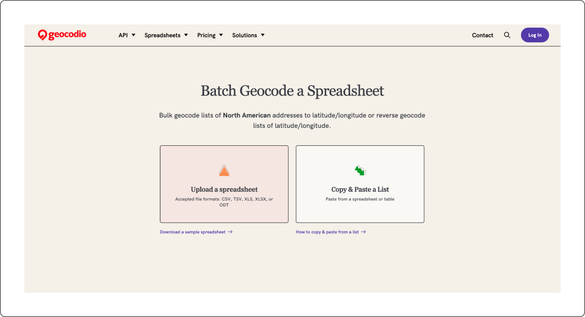
Need to geocode a spreadsheet of addresses?
You're in the right place.
Just four easy steps
Upload a CSV, Excel, or TSV file, or paste a list of addresses or coordinates directly. Geocodio matches your columns automatically, and won't overwrite any of your existing columns.
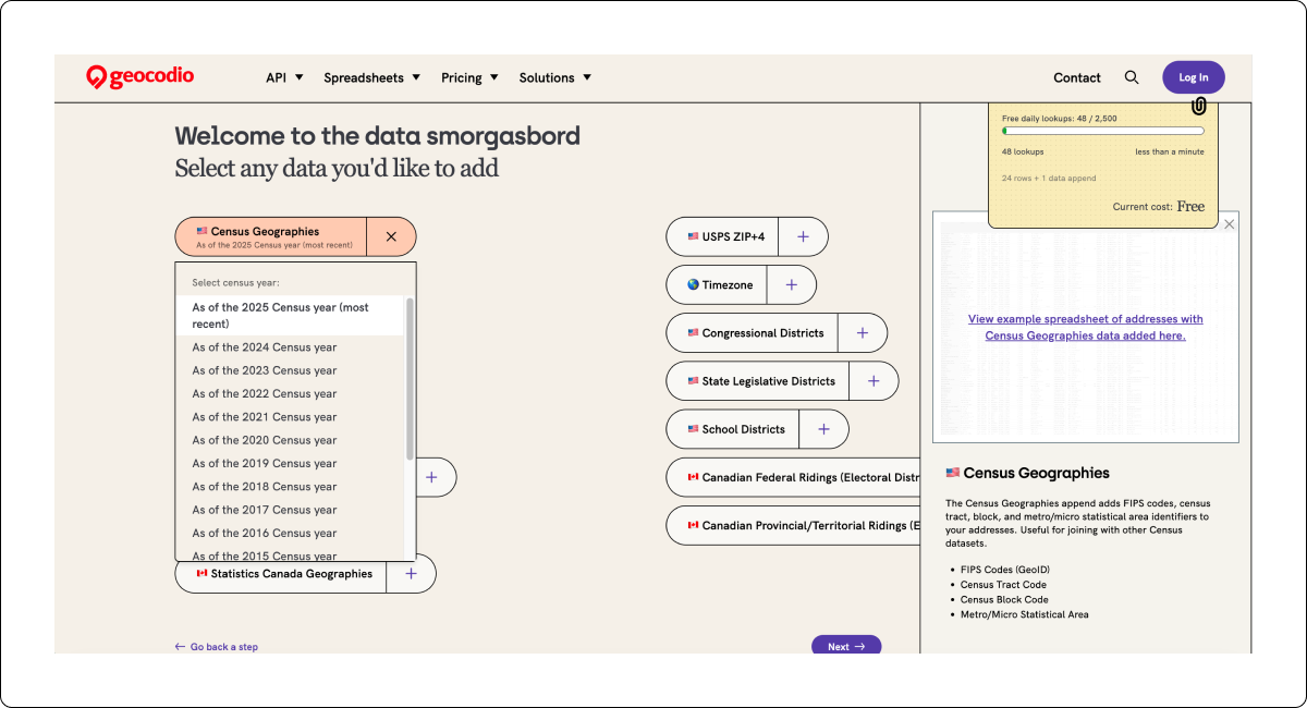
Optionally add Census data, political districts, school districts, timezones, and more to every row. All in one pass.
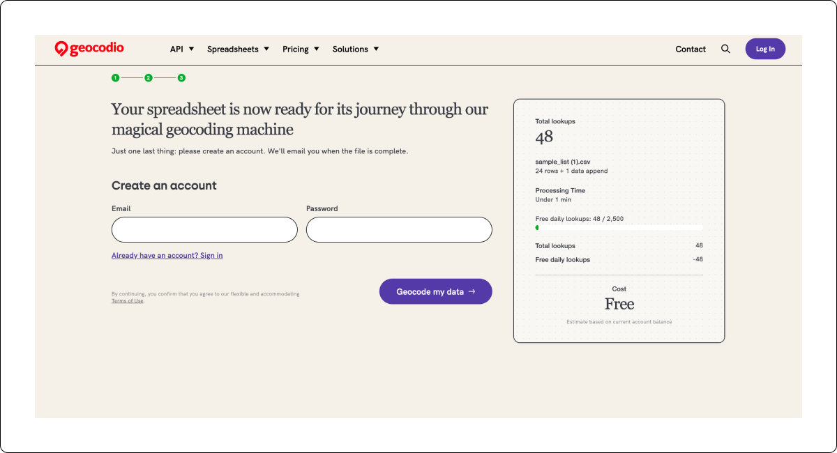
For most files, results come back in hours or even minutes.
(No need to hang around. We'll send you a email when it's done.)
Every upload includes a free interactive map (up to 100,000 points).
Add layers for Congressional districts, Census tracts, and more. Download it, share it, or come back to it later.

"I love Geocodio. I tried building Excel VBA linking to Google API but it took forever and crashed Excel constantly. I should've just gone with Geocodio to begin with!"
Ron Ding, Sales Analyst, The Sherwin-Williams Company

Raw addresses in.
Analysis-ready data out.
Raw addresses in.
Analysis-ready data out.
Address Completion
Missing pieces like county name, postal code, or more? Geocodio can add them.
Even if you've only got "100 East Main, 21157," we complete it to "100 East Main St, Westminster MD 21157". We can even add county data (Carroll County, in this case).
Address Correction
Real-world addresses come with typos, missing fields, and creative formatting. From misspelled street names to incorrect postal codes, Geocodio can correct and complete your addresses. (Go ahead. Try us.)
Address Parsing
Geocodio separates each address into its component parts and lines, even if the address arrives in one big lump.
For instance, Geocodio knows that "Apt 5A" in the address "100 East Main St Apt 5A" should be split into the Address 2 line.
Address Standardization
Get all your addresses in the same format. Got 100 West Main Street and 105 W Main St?
Now they're standardized to 100 W Main St and 105 W Main St.
Your "it just works!"
tool for geocoding spreadsheets
Big Spreadsheets Welcome: Up to 1 GB
Geocode CSV, TSV or Excel spreadsheets up to 1 GB. Run multiple files at once. Then go grab a coffee—we'll email you when it's done.
All Columns Retained
We never remove data from your spreadsheet—only add it. Feel free to leave in record identifiers or other columns.
It's Your Data, Not Ours
Geocodio will never share or sell your data, and we'll only access your files if you explicitly ask us to for support. You can delete your spreadsheets right from your dashboard whenever you want.
Your "it just works!"
tool for geocoding spreadsheets
How to format spreadsheets
✦
9.9 out of 10
✦
customers would
happily recommend
Geocodio to a friend
customers would
happily recommend
Geocodio to a friend
Based on Net Promoter Score® (NPS) survey results from 2024-2025

More than just coordinates
Enrich your data with one click
+
A smorgasbord of data appends at your fingertips. Just check the boxes during upload.
More than just coordinates
Enrich your data with one click
+
A smorgasbord of data appends at your fingertips. Just check the boxes during upload.
Census Block Group
Census Tract
Census Full FIPS
Census Block Group
Metropolitan/Micropolitan Statistical Area (MSA/CSA)
County Subdivision
U.S. Census Demographics (ACS 5-year)
Census Education
Census Veteran Status
Census Families
Census Housing
Census Income
FFIEC CRA/HMDA Data
Congressional District
Congressional Legislator Contact Info
State Legislative District (Upper)
State Legislative District (Lower)
State Legislator Contact Info
School District (Elementary)
School District (Secondary)
School District (Unified)
USPS ZIP+4 (ZIP9)
Residential Delivery Indicator (RDI)
Timezone
Canadian Federal Riding
Canadian Provincial/Territorial Riding
Statistics Canada Geographies (Census Division, etc.)
Census Block Group
Census Tract
Census Full FIPS
Census Block Group
Metropolitan/Micropolitan Statistical Area (MSA/CSA)
County Subdivision
U.S. Census Demographics (ACS 5-year)
Census Education
Census Veteran Status
Census Families
Census Housing
Census Income
FFIEC CRA/HMDA Data
Congressional District
Congressional Legislator Contact Info
State Legislative District (Upper)
State Legislative District (Lower)
State Legislator Contact Info
School District (Elementary)
School District (Secondary)
School District (Unified)
USPS ZIP+4 (ZIP9)
Residential Delivery Indicator (RDI)
Timezone
Canadian Federal Riding
Canadian Provincial/Territorial Riding
Statistics Canada Geographies (Census Division, etc.)
I am not a tech person, but I love data. Geocodio makes it incredibly easy to turn addresses into accurate geographic data at scale, saving us hours of manual effort. We have used it to identify counties, metro areas, and legislative districts. The platform is fast, reliable, and consistently delivers precise results—even with large datasets.
Rabbi Michael Namath, Director of National Campaign and Program

Very reasonable questions you might have
You can geocode CSV, TSV, and Excel files with Geocodio. Make sure your spreadsheet has headers, and put your addresses in a single column or split across columns for street, city, state, and zip. Geocodio matches your columns automatically. Full instructions here.
No. Geocodio only adds columns. Your original data stays exactly as you uploaded it.
With our self-service platform, you get 2,500 free lookups per day within North America. No credit card required. Get started here.
With our Enterprise platform, you'll get 100 free lookups when you create a demo account. Get started here.
Every upload comes with a free interactive map on your dashboard (up to 100,000 points). Customize it, download it, and share it.
Yes. The Lists API lets you upload CSV files programmatically and get results back the same way. Useful if you need to run spreadsheets on a schedule or build it into a workflow. See our docs for more.
Geocodio makes it so simple and reliable at scale. There’s a status bar that tells me exactly when my data will be ready. And if I ever have a question or troubleshooting, I know I can reach somebody who can help me.
Eliot Cresswell, Policy Analyst

You're in good hands now
Your data stays private. Real support. No bad surprises.
Reassuringly serious about data privacy
Geocodio will never share or sell your data. Your spreadsheets are yours to delete anytime, and Geocodio only accesses them if you ask for support.
Refreshingly human support that's there when you need it
When you email Geocodio, a real person will reply. No hallucinating chatbots and no scrolling through support forums to find an answer. Just people who know the product and want to help.
Plot your next step
Upload
Ready to upload a spreadsheet?
API
You can also geocode spreadsheets via API.
Guides
How to format your spreadsheet, full details on what's included with data appends, and how to create and share maps.
Plans and Pricing
Flexible, predictable pricing for projects and organizations of all sizes.