
Guides
for everything Geocodio
Guides
Australian Census Geographies
Guides
for everything Geocodio
Australian Census Geographies
The Australian Bureau of Statistics (ABS) publishes Census counts, SEIFA scores, and most other small-area statistics for areas such as SA1s and SA2s, not for individual addresses. To use that data with your own list of customers, patients, or properties, you first need to know which area each address sits in.
Geocodio's au-census append adds those areas to an API request in one step, for single addresses or batches. If you're uploading a spreadsheet, you can choose the Australian Census append in the data appends step of the upload process.
One append returns the full ABS hierarchy for each address, from the mesh block up to the state or territory, plus four classification layers: remoteness, section of state, urban centre, and significant urban area.
What are mesh blocks, SA1s, and SA2s?
The ABS builds its statistical geography, the Australian Statistical Geography Standard (ASGS), from the bottom up. Mesh blocks combine into SA1s, SA1s into SA2s, and so on, up to the state or territory. Each level fits inside the one above it without crossing its edges.
| Geography | Description | What it's good for |
|---|---|---|
| Mesh Block | The smallest ABS area, usually 30 to 60 homes. Each one has a land-use category, such as residential, parkland, or commercial | Building your own custom areas. The ABS publishes only population and dwelling counts at this level. |
| Statistical Area Level 1 (SA1) | The smallest area with full Census data, usually 200 to 800 people | The most detailed Census counts, such as age, income, and household makeup for a few streets |
| Statistical Area Level 2 (SA2) | A named, suburb-sized area, usually 3,000 to 25,000 people | Comparing suburbs across Census years, and joining other ABS data like regional population estimates and Personal Income in Australia |
| Statistical Area Level 3 (SA3) | A group of SA2s, usually 30,000 to 130,000 people, that often lines up with a council area | Regional comparisons and service planning across a group of suburbs |
| Statistical Area Level 4 (SA4) | The largest sub-state area, usually 100,000 to 500,000 people. The ABS designed SA4s for publishing Labour Force Survey data | Labour Force Survey estimates, which the ABS publishes at this level |
| Greater Capital City Statistical Area (GCCSA) | Each state's capital city area, or the rest of the state. For example, "Greater Sydney" and "Rest of NSW" | Comparing capital cities with regional Australia |
| State or Territory | The state or territory, using the ABS code (1 for New South Wales through 9 for Other Territories) | Joining state-level ABS tables |
Which level should you use?
For Census data, start with SA2. It's the level most ABS tables are published at, and the counts are large enough to be stable. Use SA1 when you need street-level detail, and keep in mind that the ABS adds small random changes to every cell, which matters more in small areas.
What data does the Australian census append return?
Here is how 83 Torrens Street, Braddon ACT 2612, an address in inner-north Canberra, fits into each level:
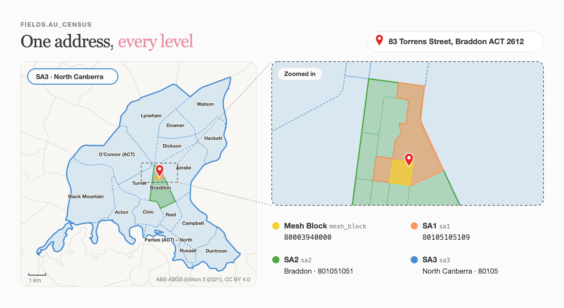
The result is keyed by year, as census is for the US, so au_census.2021 holds the 2021 geographies. Each year object has:
vintage: the ASGS edition the codes come from. ABS tables only join cleanly to codes from the same edition. 2021 uses “ASGS Edition 3”.source: the agency that published the boundaries. All ASGS boundaries are published by the ABS under CC BY 4.0.One object per layer, each with a
code, and anamefor every layer except SA1 and mesh block. Codes are strings, and GCCSA codes contain letters, so store them as text. Use this code to join ABS data to your addresses.
Each geography sits inside the one above it, so the SA1 code starts with its SA2 code, the SA2 code starts with its SA3 code, and so on up to the state or territory. For 83 Torrens Street, Braddon, SA1 80105105109 starts with SA2 801051051, SA3 80105, SA4 801, and state 8.
Four more layers in the same append
The main hierarchy tells you which statistical area an address is in. The ABS also publishes four layers that describe how urban or remote an address is, or which town or city it's part of. Geocodio returns all four:
remoteness_area: one of five classes based on how easily people there can reach services, from Major Cities of Australia to Very Remote Australia. They're the standard to compare outcomes between cities and regional or remote Australia, and government programs, such as health and education, use these classes to decide eligibility.section_of_state: one of four classes based on the size of the urban centre the address is in — Major Urban, Other Urban, Bounded Locality, or Rural Balance. The ABS counts the first two as urban Australia and the others as rural, so this field is a quick way to split a list into urban and rural addresses.urban_centre_locality: the town or city the address sits in, as the ABS defines it from population density rather than official town boundaries. This isnullwhen the address is outside every urban centre and locality, which is common in rural areas. Geocodio doesn't fall back to the nearest one.significant_urban_area: the wider town or city for places of 10,000 or more people. One SUA can group several related urban centres and is built from whole SA2s, so it takes in some of the surrounding area. This isnulloutside an SUA.
The full response schema is in the API docs.
How do I join ABS census data to my addresses?
Quick answer: Find which area level the ABS publishes your dataset for, then match its area code to the same level's code in au_census.
The ABS publishes most of its data for areas, not addresses, and each dataset uses its own set of levels:
| If you want to join… | The ABS publishes it for | Match on |
|---|---|---|
| 2021 Census DataPacks (age, income, housing, and more) | SA1 up to state, plus remoteness areas, sections of state, urban centres, and significant urban areas |
The same level's code, such as sa2.code for an SA2 DataPack
|
| SEIFA 2021 | SA1 and SA2 |
sa1.code or sa2.code
|
| Personal Income in Australia | SA2, GCCSA, and state |
sa2.code
|
| Regional population estimates | SA2 and up, plus significant urban areas and remoteness areas |
sa2.code, or the larger level you need
|
| Labour Force Survey (modelled regional estimates) | SA4 |
sa4.code
|
For example, the SA2 code for 83 Torrens Street, Braddon is 801051051. In the 2021 Census DataPack for SA2s, that row is Braddon, with a median age of 30 and a median weekly household income of $2,259.
ABS files name the code column after the level, such as SA2_CODE_2021. Keep codes as text, so spreadsheet apps don't turn 11-digit SA1 codes into scientific notation. Before you join, check that the dataset uses ASGS Edition 3, the same edition as the vintage in au_census.
Can Geocodio add the census data for me?
Yes. If you need common figures such as median age, income, or rent, three more appends return the numbers directly, with no DataPack to download. Australian Census Data covers all three:
au-demographics: population, age, and household sizeau-income: census median incomes, Personal Income in Australia, and SEIFA scoresau-housing: home ownership, rent, and mortgage repayments
Use au-census when you need to join ABS tables those appends don't cover.
Which census year does Geocodio use?
Geocodio returns 2021 census geographies on ASGS Edition 3, because that's the edition every 2021 census table is published on. Only 2021 is available today, and 2026 geographies will follow.
If you're planning work that has to stay on 2021 codes, request au-census2021 instead of au-census. A request with a year never changes. Today both return the same 2021 geographies, and requesting both returns a single 2021 key, billed once. Keep the year key and vintage with your stored results, so you always know which edition a code came from.
The demographics, income, and housing appends work differently: they have no year option and always return the newest data Geocodio has loaded. Each result names its year in meta.
Cost
Australian geocoding and coordinate lookups cost 1 credit each. The Australian census append adds 1 credit per address for every geography in it, so an Australian address with au-census costs 2 credits in total.
Australia is available on all plans, including Pay-As-You-Go. See Country support.
Related guides
Australian Census Data (demographics, housing, income, and SEIFA)
Gazetteer: town, county, and local authority (Australian councils)
Australian Electorates (federal and state)