
Updates
on everything Geocodio
Introducing New Address Lines & Updated Spreadsheet Headers
Streamlining Address Handling & Enhancing Clarity in Your Geocoding Results
Today, we're excited to announce two new features designed to make your geocoding workflow more efficient: Address Lines and "Geocodio" prefixed headers for spreadsheet results.
Address Lines
We understand that working with address components often requires extra steps to format addresses properly for your applications. That's why we're introducing address lines - a new way to access pre-formatted, multi-line address data directly from our geocoding results.
Instead of manually concatenating address components yourself, you'll now receive a neatly structured breakdown of three separate address lines. These will be included in basic geocoding responses at no additional cost.
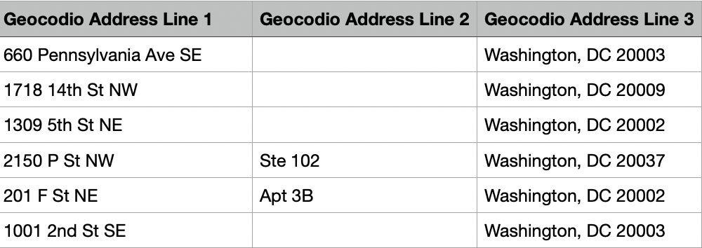
Line one includes street number and name (i.e. "168 Main St")
Line two includes suite or apartment information (i.e. "Ste 204")
Line three includes city, state and postal code data (i.e. "Hudson, NC 28638")
Along with the updated API response, we are also adding address lines to processed spreadsheets as three new columns.
What's New in the API Response?
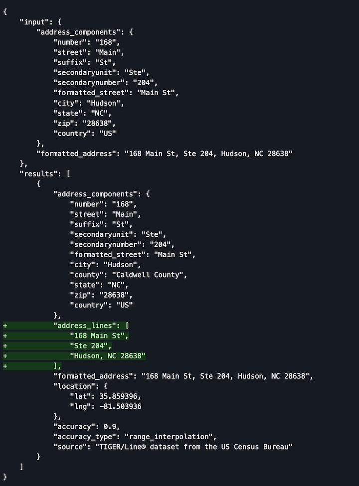
The geocoding API now includes an address_lines array in each result, containing the address broken into logical lines:
"address_lines": ["168 Main St", "Ste 204", "Hudson, NC 28638"]
What's New in Spreadsheets?
When processing spreadsheets, you'll now see three new columns:
Geocodio Address Line 1
Geocodio Address Line 2
Geocodio Address Line 3
Prefixed Spreadsheet Headers
To help you more easily distinguish between your original data and our geocoded results, we're now prefixing all basic geocoding-related spreadsheet headers with "Geocodio."
This improvement addresses a common pain point where geocoding results could potentially overlap with your existing column names, making data management cleaner and more intuitive.
All geocoding result columns will now be clearly labeled with the "Geocodio" prefix:
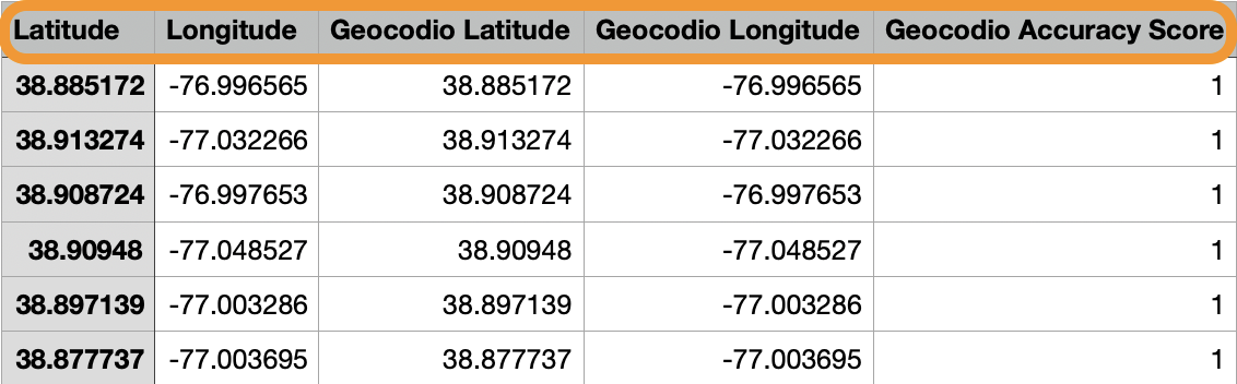
"Latitude" → "Geocodio Latitude"
"Longitude" → "Geocodio Longitude"
"Accuracy Score" → "Geocodio Accuracy Score"
We're also taking this opportunity to standardize some terminology:
"Number" is now "Geocodio House Number" (more descriptive)
"Zip" is now "Geocodio Postal Code" (more internationally friendly)
A few additional notes:
Any appended dataset headers will not receive the "Geocodio" prefix, as these headers are already unique and often quite lengthy.
For compatibility reasons, spreadsheets uploaded via the Lists API will maintain their original header format - without the "Geocodio" prefix - to avoid breaking any integrations.
These changes will only impact spreadsheet headers and not API responses.
Accessing These Changes
These improvements are available now to all Geocodio users. No action is required on your part to start benefiting from these enhancements.
Have questions or feedback about these new features? We'd love to hear from you - just reach out to our support team.
Related
FFIEC Data Append Now Available In Beta
Customers now have access to key datapoints from the FFIEC flat file, including Income Level, Urban/Rural code and more.
Lists API Now Available for Enterprise
Enterprise customers can now upload a spreadsheet directly via the Lists API.
Ridings for Canada's 2025 Election
Updated electoral districts (ridings) are available for Canada's 2025 elections.
Don't miss what's new
Geocodio ships new features and data updates regularly. We'll only email you with the good stuff, nothing else.
Thanks for subscribing! Check your inbox to confirm.