
Add Counties to Addresses
Use Geocodio to add counties to addresses from a spreadsheet
or via API
This article shows you how to add counties to addresses and coordinates using Geocodio. This can be useful for many purposes, such as clustering addresses by county using a pivot table, or mapping addresses by county. With Geocodio, you can choose to get the raw data back (via spreadsheet or API), or view the addresses on a map with county outlines.
How to Add Counties to a Spreadsheet of Addresses
Organize the addresses you want to add counties to in a spreadsheet
The first step will be to organize the addresses into a spreadsheet. Your spreadsheet will need to have headers (street, city, state or street + zip). The addresses can all be in one column or in multiple columns, as shown below, as long as it is consistent for the entire spreadsheet.
| [object Object] | City | State | ZIP |
|---|---|---|---|
| 660 Pennsylvania Ave SE | Washington | DC | 20003 |
| Address |
|---|
| 660 Pennsylvania Ave SE, Washington, DC 20003 |
You can also download an example spreadsheet here. The addresses can be missing information as long as they are all consistently formatted. For example, you can have street + zip for some addresses and street + city + state for others.
Upload the spreadsheet to Geocodio to add counties
Once your spreadsheet is organized, you can upload it directly to Geocodio. You will select the columns where your data is, see an example of the results, and be able to optionally add on other data (such as Congressional districts or Census tracts). Counties are included by default with geocoding.
If you'd prefer to upload your spreadsheet programmatically, you also have the option to integrate with our Lists API.
Download your completed spreadsheet with counties added
You will receive an email when your spreadsheet is done processing -- no need to stay on the page. You can download an example result of a spreadsheet of addresses with counties added here.
How to Add Counties to a Spreadsheet of Latitude/Longitude Coordinates
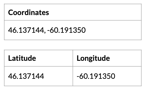
Organize the latitude/longitude coordinates you want to add counties to in a spreadsheet
The first step will be to organize the latitude/longitude coordinates into a spreadsheet. Your spreadsheet will need to have headers. Latitude/longitude can be in one column combined, or separated, as shown below, as long as it is consistent for the entire spreadsheet.
Upload the spreadsheet to Geocodio to add counties
Once your spreadsheet is organized, you can upload it directly to Geocodio. You will select the columns where your data is, see an example of the results, and be able to optionally add on other data (such as Congressional districts or Census tracts). Counties are included by default with geocoding.
If you'd prefer to upload your spreadsheet programmatically, you also have the option to integrate with our Lists API.
Download your completed spreadsheet with counties added
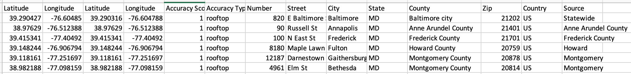
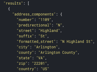
You will receive an email when your spreadsheet is done processing -- no need to stay on the page. When you upload coordinates, we'll add the closest street address, city, county, and state, like this. You can download an example result for a spreadsheet of coordinates with counties added here.
Make a Map of Addresses with County Outlines
You can also use Geocodio Maps to show a map with county outlines.
If you've already uploaded the file above, you would click "Edit in Geocodio Maps" from the dashboard.
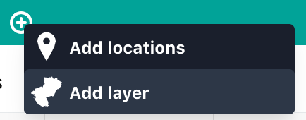
Add county layer to map
Upon opening the map, you would then click the plus button next to the file name and select "add layer."
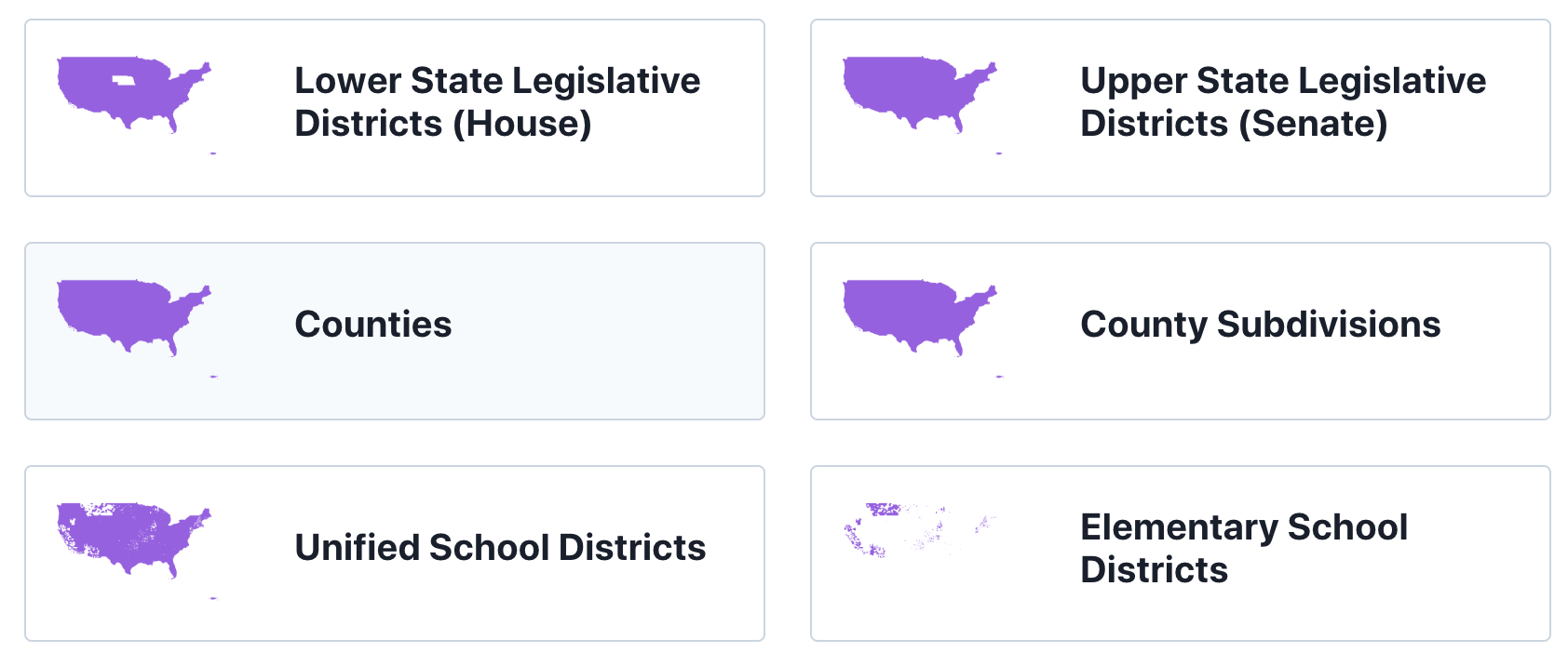
Select County or County Subdivision
Next you would select Counties or County Subdivisions (the latter being the Census Bureau's terminology and definition).
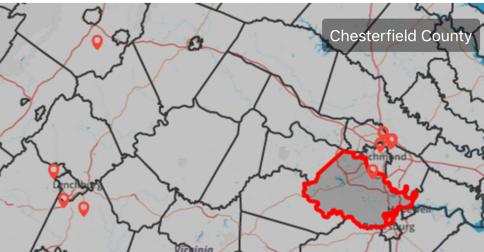
View County Outlines on the Map
Now you should see the county outlines on the map, as below:
Adding Counties to Addresses via API
You can also use the Geocodio API to add counties. You can do single requests for real-time geocoding, or use our batch geocoding endpoint to do batches of up to 10,000 lookups at a time. Multiple batches can be run in parallel. See more in our documentation here.
Any questions? Please feel free to reach out to us.
Video: How to Add Counties to a Spreadsheet of Addresses
Video transcript
This video shows you how to geocode a spreadsheet of addresses using Geocodio. With Geocodio, you can turn US or Canadian addresses into coordinates. You can also complete addresses and add county information.
Starting out, we're going to look at our spreadsheet. You'll notice it has a header for address, city, state, and ZIP. You can also have all of your addresses in one column, and you can see on Geocodio's website that there are multiple different formats. You can go to https://www.geocod.io/, go to Guides (https://www.geocod.io/guides), and go to Spreadsheet Formatting (https://www.geocod.io/guides/preparing-your-spreadsheet/). There you can download an example file, both in the single column format and in the multiple column format, and you can also download an example geocoded result. Looking again at our file, you'll notice that not all of the addresses are complete. For example some of them have street, city, and state, and some of them have street and only the zip code. As long as you have at least street and zip code or street city state, Geocodio can complete the addresses and add the coordinates for you. Geocodio will also add county information to that list as well.
So now we're going to go to https://www.geocod.io/upload/. We can either drop or select our spreadsheet from our files, or we can paste in a segment of addresses. Next we're going to confirm the columns, so that address is indeed in Column A, city is in Column B, and so forth. Note that if we had addresses in Canada, we would need to have a Country column with "Canada" given exactly. And here we can see a preview of what Geocodio is seeing. We can also see a map preview here as well.
Next we can add any additional data that we might need, for example timezones, Census FIPS codes, Congressional districts or Ridings in Canada, USPS ZIP+4 data, Census data such as household income or demographics, school districts, or state legislative districts.
Before we start the process we can see an estimate below, so this is only 50 rows and the first 2,500 lookups are free per day, so there is no cost for this, and the processing time is expected to be less than a minute, so we'll press start. And now we will be able to see that the file is being geocoded. Note that you don't have to stay on this page, you will receive an email when it's complete. Our file has already finished processing, so we're going to download that. And now we can see the completed file with the parsed addresses and the county information added to it, as well as of course the latitude and longitude.
Related Resources
Batch Geocoding API Documentation
Use our API to add counties to single addresses or batches of addresses.