
Updates
on everything Geocodio
Streamlining Geocodio's Redistricting Tracker
Preparing for mid-cycle redistricting with clearer data status
At Geocodio, we pride ourselves on providing up-to-date Congressional and state legislative district boundaries. As several states move forward with efforts to re-draw their Congressional or state legislative districts, we expect our Redistricting Tracker to become essential in the coming weeks and months. We're using this opportunity to streamline our district tracking methodology and give you what you really need: information on whether Geocodio has up-to-date boundaries for impacted states.
The Geocodio Redistricting Tracker
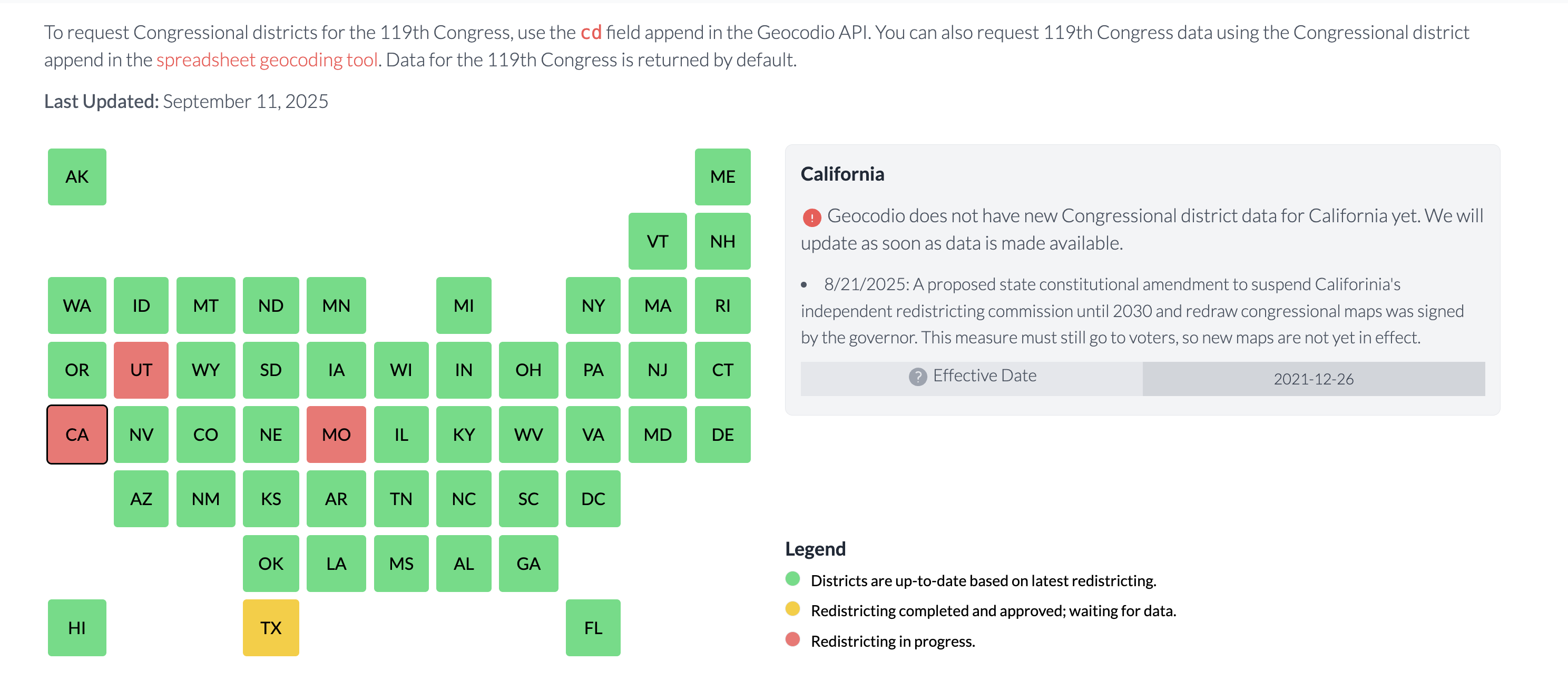
On our Redistricting Tracker, you can see which states have passed new districts, whether new maps have been made available by the states, and whether Geocodio is returning the new districts.
We research and track which states are up-to-date in our database, which states have made serious steps towards redistricting, which have passed map changes but haven't released map data yet, and which haven't updated their maps at all. When possible, we also include short news updates regarding the status of a given state.
States are color-coded as follows:
Green: Districts are up-to-date based on the latest redistricting information. States in litigation remain "up-to-date" until court cases are settled and decisions made.
Yellow: Redistricting legislation was passed and signed by the governor of the state, but map data isn't yet publicly available.
Red: Redistricting is in progress but not passed by legislature or signed by governor. (Also used when courts force states to re-draw maps.)
Background: Tracking Redistricting at Geocodio
Traditionally, most activity happens at the beginning of each decade when states implement new district boundaries. However, we monitor during off-years as well since Congressional and state maps sometimes change mid-cycle due to litigation or court decisions.
Recently, states including Texas, California and Missouri have proceeded with legislation that could lead to broader mid-cycle redistricting efforts. Other states have also discussed early redistricting as a possibility, though have made less concrete steps to move forward. We’re prioritizing the monitoring of these states to ensure that our Congressional and State Legislative district data stays accurate and up-to-date as we move into a new federal election year.
During the lead-up to the 2024 election, over a dozen states were in active litigation regarding the political maps they implemented during the 2022 redistricting deadline. This left their map data in limbo — boundaries were up-to-date based on what state legislatures passed, but could change pending lawsuit results.
If you went to the Redisticting Tracker before this update, you would have seen this color-coding:
Green: Geocodio has updated Congressional district data for 2022
Red: Geocodio does not yet have 2022 Congressional district data
Yellow: Congressional districts passed but in litigation, waiting on decision
Blue: State didn't change Congressional districts in 2022
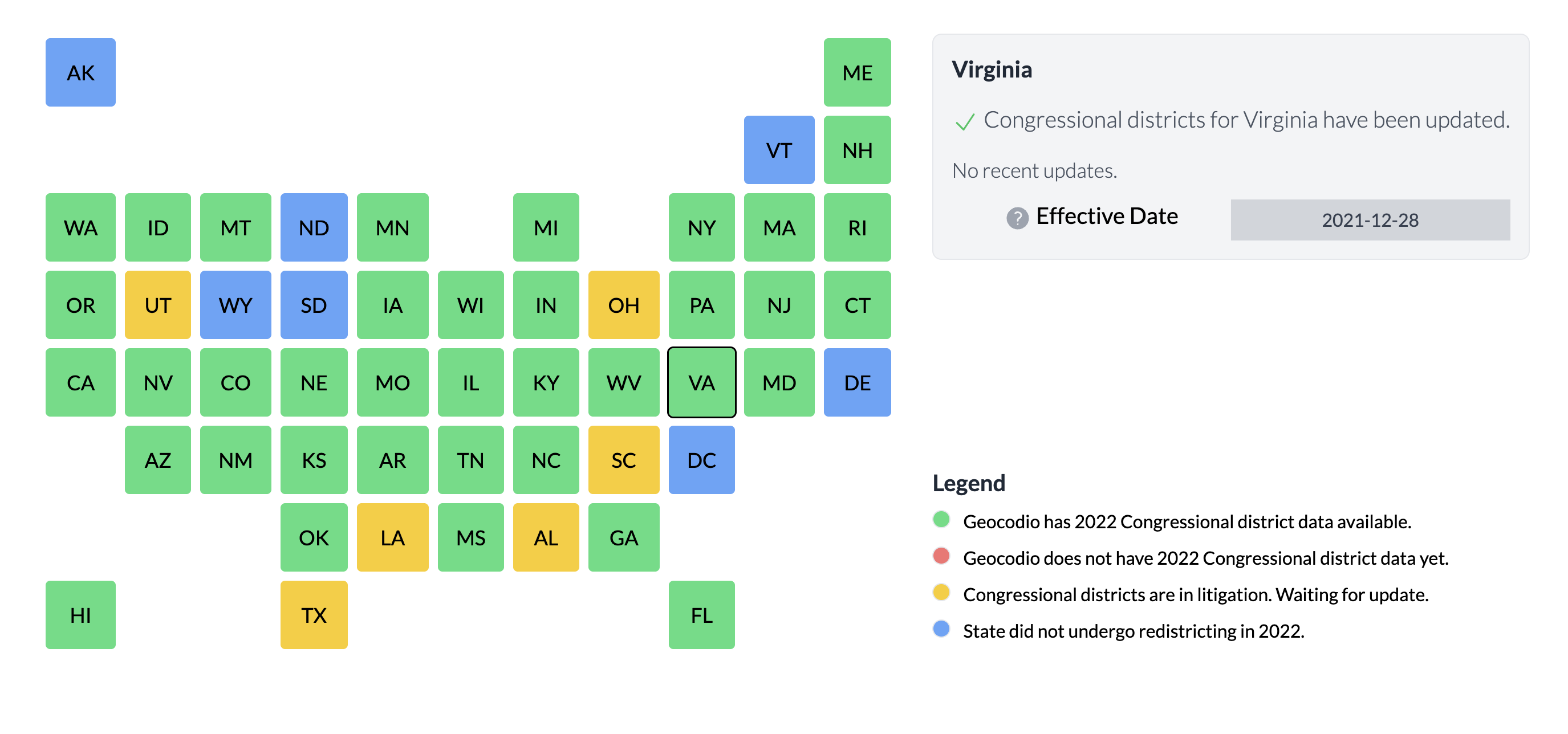
Note
The Blue category most often referred to states with a single Congressional district that encompassed the entire population of the state.
As we enter a period where select states are choosing mid-cycle redistricting, we're clarifying these categorizations to make them easier to understand. We're no longer using a separate category for states in litigation. Many lawsuits from the 2024 election cycle have been settled, especially at the federal level, making this information less essential.
We'll still monitor and provide litigation news updates when you click on specific states, but potential changes that haven't officially begun won't be reflected in the color-coding.
We’ve also elected to stop tracking single-district states that didn’t change during the redistricting period.
Our intent is to give you the information you care about most when deciding to append our Congressional or State-Level district datasets: whether we're returning the newest, most current district maps from the states.
Questions or Feedback?
If you’re using Geocodio to look up Congressional districts or state legislative districts using our spreadsheet geocoding tool or API, use Geocodio's Redistricting Tracker to follow which state legislative and Congressional district maps have been updated in our database.
If you have feedback on our new methodology or questions about any impacted state and its district boundaries, email us at [email protected]. As always, you'll get a friendly human who is eager to help.
Related
Congressional Districts & Contact Info
A guide to add Congressional Districts and legislator information to your results.
State Legislative Districts & Legislators
A guide to add State Legislative Districts and legislator information to your results.
Congressional District API Documentation
Learn how to implement Congressional District data into your API calls.
Address or Coordinates to Congressional District
See how to convert addresses or coordinates to Congressional districts.
Geocodio Now Grants 100,000 Free Lookup Credits to Journalists
Geocodio will now grant 100,000 free lookup credits to journalists to help power data-driven reporting. All we ask is that you cite us as a source — which you would anyway.
Don't miss what's new
Geocodio ships new features and data updates regularly. We'll only email you with the good stuff, nothing else.
Thanks for subscribing! Check your inbox to confirm.