
Bulk Lookup Census FIPS Codes, Blocks, and Tracts
How to add Census FIPS codes, blocks, tracts, MSAs/CSAs to a spreadsheet of addresses or via API
Are you working with addresses that you need to connect to government datasets? Most government data is published at the FIPS code level. To connect your data, you'll need to find the FIPS codes, or perhaps the Census Tracts or Blocks, for the addresses. Geocodio can help you convert the data quickly.
Geocodio can also help you add historical (past-year) Census FIPS codes, blocks, and tracts to addresses or coordinates. Data is available for the 2000 and 2010-2025 Census years.
# This code block gets replaced with the TOCOur Census data append includes:
Census year
State FIPS
County FIPS
Place Name
Place FIPS
Full FIPS (concatenation of State, County, and Place)
Tract code
Block code
Block group
Metro/Micro Statistical Area (MSA)
Combined Statistical Area (CSA)
Metropolitan Division
County Subdivision: Minor Civil Division (MCD) / Census County Division (CCD)
More of a visual learner? Skip to video
First: Decide whether you want to add FIPS codes to addresses or coordinates via API or spreadsheet
Geocodio has two ways to add state and county FIPS, block and tract codes, and block groups via API or spreadsheet upload. The cost is the same for both, and both the API and spreadsheet uploads are included with our Unlimited plan.
You may find yourself needing both an API and spreadsheet uploads to fetch FIPS codes. For example, let's say you're a bank. You may have your loan book for several years that you need to run through first, so it might make sense to upload your data in spreadsheet form to backfill. Then you could integrate our API for new loans on an ongoing basis.
Add FIPS Codes and Block/Tract IDs to a Spreadsheet (Excel file, CSV)
This section walks you through how to add FIPS codes, block/tract IDs, and MSAs/CSAs to a spreadsheet. Instructions on using our API follow.
1. Gather the addresses or coordinates you want to find the FIPS codes, Census blocks, and Census tracts into a spreadsheet
First you will need to collect all of the addresses or coordinates you want to convert to FIPS codes, blocks, and tracts. Your file needs to have headers and the formatting should be consistent. See how to format your spreadsheet here.
2. Upload the spreadsheet of addresses or coordinates to Geocodio to add FIPS codes, Census blocks, and Census tracts
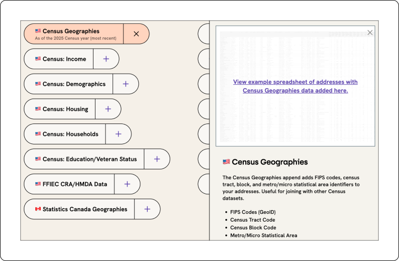
If your addresses or coordinates are in a spreadsheet, you can upload it to Geocodio. In Step 3 of the Upload process, you'll be given the option to add additional data:
For the US, you'll want to select Census Identifiers. When you add this append, we'll return several different Census geographies for the address or coordinate, including Census year, State FIPS, County FIPS, Place Name, Place FIPS, Tract code, Block code, Block group, Metro/Micro Statistical Area (MSA), Combined Statistical Area (CSA), Metropolitan Division, and County Subdivision (Minor Civil Division / Census County Division). You can see a sample output here.
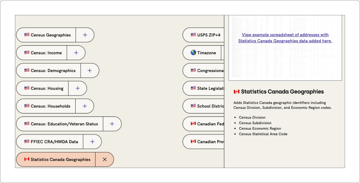
For Canada, you'll want to select Canadian Census Identifiers. This will add Statistics Canada geographic identifiers such as divisions, economic regions, and tract IDs. See the full list here.
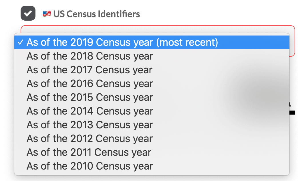
3. For US Only: Select Census Year Data to Add to Addresses
After you check the box for Census Identifiers, a drop-down will appear that will allow you to select the Census Year that you'd like. 2010-present are available. (If you want to add multiple Census years at a time, we suggest using the API.)
Alternatively, use our API to turn addresses or coordinates into FIPS codes, Census blocks, and Census tracts
Using our API, you'll just need to add the &fields=census for the US and &fields=statcan for Canada parameter to your requests . See more in our documentation here.
VIDEO: How to Add FIPS Codes, Census Blocks, and Census Tracts to a Spreadsheet of Addresses
This video shows you how to add Census FIPS codes to a spreadsheet of addresses. Note that this will also work with coordinates as well.
Step 1: Format your spreadsheet
First we're going to start out with a spreadsheet of addresses. We have them split into separate columns with headers for address, city, state, and zip code, and note that the addresses don't have to be complete. Geocodio will complete the addresses and add the county as well. And to see how you can format your spreadsheet, you can go to https://www.geocod.io/, click on Help, click on Guides, and then go to Spreadsheet Formatting (https://www.geocod.io/guides/preparing-your-spreadsheet/). And there you can download sample files and you can also download an example geocoded file. In addition, since we're working with FIPS codes here, you can go to Census (https://www.geocod.io/guides/census/) and you can download an example geocoded result with Census FIPS codes, MSAs/CSAs, blocks, and tracts added.
Step 2: Upload your spreadsheet to Geocodio
Once our spreadsheet is formatted, we can go to https://www.geocod.io/upload and upload the file. We can either drop it or select it, or we can also paste in addresses or coordinates if we for example have a larger file and only need to work with a small segment of it.
So we're going to drag in our file. Then we will confirm all of the headers that are mapping over to the columns. We can see a preview of the addresses here. We can also see a preview of them on the map. Then in Step 3 we can add on other data, such as timezones, ZIP+4, and Census data. To add FIPS codes, we will click US Census Identifiers. This will add on the data to our spreadsheet, it will not delete any data on the spreadsheet. We will click continue.
We'll see an estimate below, so our list had 50 rows of addresses, plus one data append, so that will count as 100 lookups. And the first 2,500 lookups per day are free, so this file will not cost us anything, and the processing time is estimated to be less than a minute. Press Start.
Step 3: Download your spreadsheet
Now we do not have to stay on this page and wait for it to process, you will receive an email when the file is done processing. However, this is a very short list, so it is already done, so we can now download the spreadsheet.
And here we can see our spreadsheet with the FIPS codes, Census tracts, Census blocks, and the Metro/Micropolitan Statistical Areas. And note that it's quite common for Excel to do this where it will truncate the full FIPS, but as you can see in the formula bar, the full FIPS code is indeed there.
Related Resources
Download a sample result
Download a sample geocoded spreadsheet with FIPS, Census blocks, and Census tracts added
API to Add FIPS, Blocks, and Tracts
The Geocodio API can help you geocode addresses and add FIPS, Census blocks, and tracts all in one request. blocks, and tracts all in one request.
Complete Guide to FIPS Codes
Everything You Need to Know About Federal Information Processing Standards Codes
API Documentation
Use the Geocodio API to add Census geographies to addresses or coordinates.
Financial Services
Banks, mortgage lenders, insurers, and other financial services companies use Geocodio as part of their compliance and risk assessment processes.
Is the Census Bureau API Down?
"Experiencing Census Bureau API downtime, 'could not resolve host' errors, or 'system is busy' messages? Geocodio provides a reliable alternative to get Census data."