
Complete Guide to FIPS Codes: What They Are and How to Look Them Up in Bulk
Everything You Need to Know About Federal Information Processing Standards (FIPS) Codes
Quick Answer
A FIPS code (Federal Information Processing Standards code) is a standardized numeric identifier used by the U.S. government to uniquely identify geographic areas, from states down to census blocks. Defined by the U.S. Census Bureau and developed by NIST, these codes ensure consistent data collection and reporting across federal agencies.
What is a FIPS Code?
FIPS codes create a hierarchical system that allows precise geographic identification. Think of them as a detailed address system for government data: each level of geography gets its own unique number that fits into a larger organizational structure.
FIPS codes are often used to connect an address to government datasets, such as Census datasets on demographics or economic factors. They're also required for many compliance-related uses.
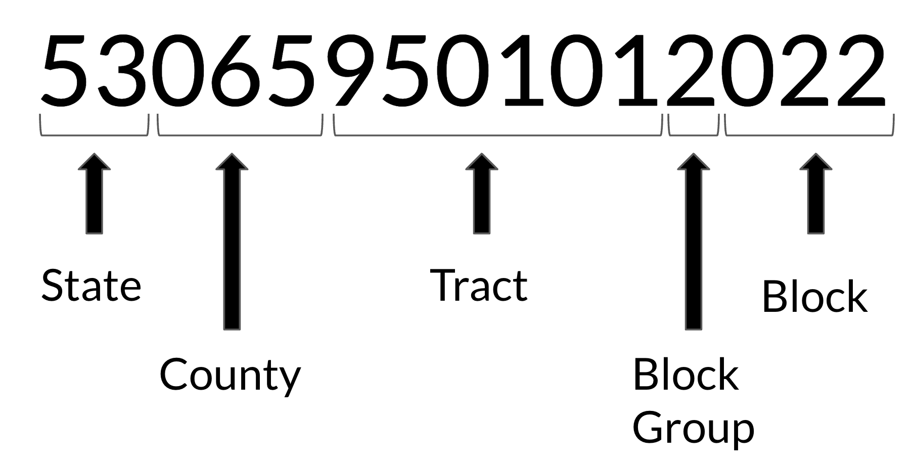
What are the components of FIPS codes?
FIPS codes come in several formats depending on the level of geographic detail you need:
5-digit FIPS codes identify states (2 digits) and counties (3 digits). For example, California's state code is 06, and Los Angeles County's full FIPS code is 06037.
11-digit FIPS codes include census tract information, combining the 5-digit state and county code with a 6-digit census tract identifier.
15-digit FIPS codes provide the most detailed geographic precision, adding a 4-digit census block number to the 11-digit format.
The exact number of possible FIPS code combinations depends on how many geographic divisions exist within each level. With 50 states, over 3,000 counties, approximately 85,000 census tracts, and hundreds of thousands of census blocks, the total combinations reach into the millions.
Do FIPS Codes Change Every Year? (Or: Why FIPS Code Year Matters: The Critical Importance of Using the Right Vintage)
Understanding which year your FIPS codes represent is crucial for accurate data analysis and regulatory compliance. FIPS code boundaries change over time, and using the wrong vintage can lead to significant errors in your analysis or compliance reporting.
Geocodio allows you to select the FIPS Code year (2000, 2010-2025) when you use our APIs or spreadsheet geocoding tool.
Decennial Census Boundary Changes: Every ten years, the U.S. Census Bureau redraws Census tract and block boundaries based on population changes. These updates can significantly alter FIPS codes for the same physical addresses. For example, a rapidly growing suburban area might have its Census tracts split, creating entirely new FIPS codes where none existed before. Though rare, Census tracts and boundaries can change between decennial censuses.
Government Dataset Matching Requirements: Federal agencies typically specify which FIPS code vintage to use for their programs. The American Community Survey could for example use 2020 Census boundaries for current data, while historical analyses might require 2010 boundaries. Mixing FIPS code vintages when joining datasets can result in addresses that don't match properly, leading to incomplete analysis or compliance failures.
FIPS Codes for Legal and Regulatory Compliance: Many federal programs have strict requirements about FIPS code vintages:
Community Development Block Grant (CDBG) eligibility determinations must use the census tract boundaries that were in effect when the program guidelines were established
Opportunity Zone designations are locked to 2010 census boundaries. You must use 2010-vintage FIPS codes to determine eligibility
Low-Income Housing Tax Credit programs often specify particular census years for income qualification thresholds
Environmental Justice screening tools require matching the FIPS code vintage to the demographic data being analyzed
Research Integrity: Academic and policy research requires temporal consistency. A study that uses Census data to analyze neighborhood change from 2015 to 2025 needs FIPS codes that reflect the boundaries in effect during each time period. Using current FIPS codes for historical data can create artificial trends that don't reflect actual geographic changes.
Business Impact Examples: A retail chain analyzing customer demographics might see false market shifts if they use 2020 FIPS codes to analyze 2015 sales data, especially in areas where census boundaries changed significantly. Financial institutions face similar challenges when demonstrating CRA compliance across multiple years—they must use the FIPS codes that were current when each loan was originated.
FIPS Code vs ZIP Code: What's the Difference?
While both FIPS codes and ZIP codes help identify locations, they serve different purposes and have different geographic definitions.
ZIP codes were created by the United States Postal Service for mail delivery efficiency. They are not geographic boundaries. They're postal codes and can change frequently. They don't always align with political or statistical boundaries. A single ZIP code might cross county lines or even state lines in some cases. ZCTAs from the Census are approximate boundaries based on the postal route, but are not designated or approved by the USPS.
FIPS codes follow official government boundaries that remain more stable over time. They're designed for statistical analysis and government reporting. This makes them more reliable for demographic research and policy analysis.
For example, you might live in ZIP code 90210, but your FIPS code would be 06037700100. This indicates California (06), Los Angeles County (037), and your specific census tract (700100).
What is My FIPS Code? How to Find FIPS Codes
Finding your FIPS code or looking up FIPS codes for specific addresses can be accomplished through several methods:
Single Address Lookup: If you need to find one FIPS code, you can use online tools that accept your street address and return the corresponding FIPS identifiers. Geocodio offers a straightforward FIPS code lookup tool that provides accurate results for any U.S. address.
Bulk FIPS Code Lookup: When you need FIPS codes for multiple addresses—whether dozens or millions—bulk lookup services become essential. These tools can process large datasets efficiently while maintaining accuracy.
Services for Bulk FIPS Code Lookup
Several services can help you perform bulk FIPS code lookup operations:
Government Resources: The U.S. Census Bureau provides the official TIGER/Line files and American Community Survey data with FIPS codes. These datasets require GIS software and technical expertise to process effectively. The Census Geocoder API offers limited bulk processing and has strict usage limits.
Google Maps Platform: Google's Geocoding API can return FIPS codes as part of Region Lookup API. It's unclear what the year of the FIPS codes returned by Google are. Bear in mind that Google's geocodes cannot be stored and can only be cached for 30 days.
Mapbox: The mapping-focused service Mapbox provides FIPS codes through their context data feature. They offer competitive pricing for bulk operations, though FIPS data isn't their primary focus.
Smarty: This address validation service includes FIPS codes in their US Street API responses. They offer both single address lookups and bulk file processing. Their documentation does not state the year of the FIPS code, and they do not provide historical FIPS codes.
Geocodio: As a specialized geocoding service, Geocodio excels at both single and bulk FIPS code lookup operations. You can upload spreadsheets with thousands or millions of addresses and receive comprehensive FIPS code data, including state, county, and census tract information—all with the Census vintage you've specificed with just one click. Geocodio offers transparent pricing, historical FIPS codes, and handles the largest datasets efficiently.
Texas A&M Geoservices: The university provides a free geocoding service that includes FIPS codes, though it has rate limits and may not be suitable for commercial use or very large datasets. They provide FIPS codes for 1990, 2000, 2010, and 2020.
ArcGIS World Geocoding Service: Esri's enterprise solution provides FIPS codes as part of their comprehensive geocoding platform.
Each service has different strengths. Google and Mapbox excel at international coverage. Smarty focuses on address validation. Geocodio specializes in U.S. geocoding and data enrichment with transparent pricing and excellent bulk processing capabilities.
How to Get FIPS Codes in Excel
Getting FIPS codes directly in Excel requires connecting to external data sources or APIs. Here are your main options:
Spreadsheet Upload Method: The most user-friendly approach involves uploading your Excel spreadsheet to a geocoding service. Geocodio makes this process simple—upload your file with addresses, check the box to add FIPS codes and specify the year, and download the results with FIPS codes added to your data.
API Integration: For users comfortable with Excel's data connection features, you can connect to FIPS code lookup APIs directly within Excel. This requires setting up API calls and parsing the returned data.
Manual Lookup: For small datasets, you might manually look up FIPS codes and enter them into your spreadsheet, though this becomes impractical for more than a few addresses.
The spreadsheet upload method offers the best balance of simplicity and capability for most users who need FIPS codes in Excel.
How to Get FIPS Codes via API
API access provides the most flexible way to integrate FIPS code lookup into your applications and workflows:
RESTful APIs: Most geocoding services offer REST APIs that accept address data and return FIPS codes along with other geographic information. These APIs typically support both single address queries and batch processing.
Rate Limits and Pricing: Different services have varying rate limits and pricing models. Some charge per lookup, while others offer subscription-based pricing for high-volume users.
Data Format: APIs usually return FIPS codes in JSON or XML format, along with additional geographic data like coordinates, administrative boundaries, and demographic information.
Geocodio's API provides reliable FIPS code lookup with straightforward documentation and competitive pricing, and you can lookup FIPS codes for addresses on-the-fly, in batches, or via CSVs.
Historical FIPS Code Lookup
Historical FIPS codes become important when working with data from specific time periods, as boundaries and codes can change over time.
Why Historical Data Matters: Census boundaries are redrawn every ten years, and counties occasionally split or merge. Using the correct historical FIPS codes ensures your analysis reflects the geographic reality of your chosen time period.
Available Years: Most services providing historical FIPS codes focus on decennial census years (2010, 2020, etc.) when major boundary changes typically occur.
Geocodio provides FIPS codes at a more granular level, providing FIPS codes for every year 2010-2025 as well as 2000.
Getting FIPS Codes for Large Address Lists by Year
When you need FIPS codes for thousands or millions of addresses for a specific year like 2020 or 2021, you have several options:
Census Bureau Data: The official source for historical boundary data, but requires significant technical expertise to process effectively.
Commercial Geocoding Services: Services like Geocodio specialize in processing large address lists with historical accuracy. You can specify the year you need and process millions of addresses efficiently.
Hybrid Approaches: Some organizations combine multiple data sources to ensure comprehensive coverage and accuracy for their specific use cases.
For most users dealing with large datasets, commercial services provide the best combination of accuracy, speed, and ease of use. Geocodio can handle looking up FIPS codes for millions of addresses while maintaining historical accuracy for your specified time period.
Using Geocodio for FIPS Code Lookup
Geocodio specializes in making location data accessible and accurate. Whether you need a single FIPS code or bulk processing for millions of addresses, Geocodio provides reliable solutions.
Single Address Lookup: Simply enter any U.S. address here and select the box for US Census Identifiers to receive comprehensive FIPS code information, including state, county, and census tract identifiers.
Bulk Processing: Upload spreadsheets with your address data and receive processed results with FIPS codes added. You can also geocode and enrich with FIPS programmatically with the lists API endpoint. Remember to check the box for Census geographies or use the
censusfield append.Historical Accuracy: Specify the year you need for your analysis, and Geocodio will provide FIPS codes that were accurate for that time period.
API Access: Integrate FIPS code lookup directly into your applications with Geocodio's straightforward API.
The service maintains high accuracy standards while keeping the process simple and accessible for users at any technical level.
Best Practices for FIPS Code Lookup
Verify Your Time Period: Always specify the year you need for your analysis, especially when working with historical data, compliance, or multi-year studies.
Clean Your Address Data: Standardized, complete addresses produce more accurate FIPS code results. Include street numbers, street names, city, state, and ZIP codes when available.
Understand Your Precision Needs: Determine whether you need county-level (5-digit), census tract (11-digit), or census block (15-digit) precision before beginning your lookup process.
Plan for Data Volume: Consider your processing needs early. Single lookups work fine for small projects, but bulk processing becomes essential for larger datasets.
Validate Results: Spot-check your results, especially when working with addresses near boundary lines where slight variations in address formatting might affect accuracy.
Common Use Cases for FIPS Code Data
FIPS codes serve many important purposes across different industries and applications:
Demographic Analysis: Researchers use FIPS codes to link addresses with census demographic data for market research, public health studies, and policy analysis. For example, retail chains use FIPS codes to analyze customer demographics within specific census tracts to optimize store locations and product mix. Public health officials track disease outbreaks by census tract using FIPS codes to identify geographic patterns and allocate resources effectively.
Government Compliance: Many federal programs require FIPS code reporting for funding allocation and program administration. The Community Development Block Grant (CDBG) program uses FIPS codes to determine funding eligibility based on census tract poverty levels. The New Markets Tax Credit program requires FIPS code documentation to verify that investments target qualified low-income communities. Healthcare providers must report FIPS codes for Medicare and Medicaid reimbursement under various federal programs.
Banking and Financial Services: The Community Reinvestment Act (CRA) requires banks to report lending activity by census tract using FIPS codes. Financial institutions use this data to demonstrate compliance with fair lending requirements and community investment obligations. The Home Mortgage Disclosure Act (HMDA) mandates FIPS code reporting for mortgage applications and originations. The Equal Credit Opportunity Act (ECOA) requires demographic reporting using FIPS codes.
Business Intelligence: Companies use FIPS codes to analyze customer distributions, plan service areas, and understand market penetration at the census tract level. Insurance companies leverage FIPS codes to assess risk profiles and set premiums based on geographic factors like crime rates, natural disaster frequency, wildfire rates, and demographic characteristics. Real estate investment firms use FIPS codes to identify emerging markets by analyzing census tract-level economic indicators and population growth trends.
Environmental and Energy Programs: The Environmental Protection Agency uses FIPS codes for environmental justice screening tools. This ensures that pollution monitoring and cleanup efforts consider demographic factors. The Department of Energy's Weatherization Assistance Program uses FIPS codes to identify eligible low-income areas for energy efficiency upgrades.
Academic Research: Scholars studying geographic patterns, social trends, and economic development rely on FIPS codes to ensure accurate spatial analysis. Education researchers use FIPS codes to link school district performance with community demographics. Sociologists track residential segregation patterns using FIPS codes to analyze housing and demographic trends across census tracts over time. Many researchers use Geocodio to add FIPS codes to their data.
Emergency Management: FEMA uses FIPS codes for disaster declaration processes and resource allocation. Emergency responders use FIPS codes to coordinate multi-jurisdictional responses and ensure accurate damage assessments for federal disaster relief funding.
Understanding FIPS codes and having reliable lookup tools helps ensure your location-based analysis meets professional standards while saving time and reducing errors.
Conclusion
FIPS codes provide essential geographic standardization for countless applications across government, business, and research. Whether you need a quick single address lookup or bulk processing for millions of records, understanding your options helps ensure accurate results.
From simple online lookups to sophisticated API integrations, various tools can meet your FIPS code needs. Services like Geocodio specialize in making this process accessible and reliable, whether you're working with current data or need historical accuracy for specific time periods.
The key to successful FIPS code lookup lies in choosing the right tool for your specific needs, understanding the level of precision required, and maintaining data quality throughout your process. With proper planning and the right resources, FIPS codes become a powerful foundation for location-based analysis and reporting.
Related Resources
Bulk Lookup Census FIPS Codes, Blocks, and Tracts
How to add Census FIPS codes, blocks, tracts, MSAs/CSAs to a spreadsheet of addresses or via API
Census Geographies (Block/Tract/FIPS/GeoID)
You can upload a spreadsheet of addresses or coordinates to Geocodio to bulk lookup Census geographies such as Census blocks, tracts, and FIPS codes. Census boundaries are available for every year back to 2010 as well as 2000.
Census FIPS API
Add FIPS Codes, Census Tracts, Census Blocks and more to addresses or coordinates via API.
By the time you finish reading this page, the Geocodio API will have processed 5.3 million lookups.
Your data could be next...