 December 17, 2025
API v1.9: Census 2025 geographies now available
Geocodio’s Census data append now returns the most recent geographies (FIPS Codes) released in 2025
Easily append the latest Census geographies (FIPS Codes) to addresses with Geocodio
Geocodio can append various Census FIPS codes to an address or coordinate pair, including Census Tract, Census Block, MSAs/CSAs, and more.
The census2025 data append is now available. If you select the Census data append and don't specify a year, it will now default to 2025 Census geographies.
See our knowledge base and API docs for more on appending Census FIPS codes.
You can match addresses to vintage Census FIPS Codes with Geocodio, too
When you're working with US government datasets, it's important that the FIPS codes for your address data match the Census year of the dataset. FIPS Codes can change from year to year, and if you aren't using the same Census year as the dataset(s), it can impair your data analysis.
If you're looking for vintage Census geographies, Geocodio provides full geographies for every year back to the 2010 Census (2010-2025). You can do this by specifying the year together with the field name, such as census2015 for 2015 Census geographies, or by selecting the desired year in the drop-down menu when geocoding a spreadsheet.
When using the Geocodio API, it is also possible to request multiple years at the same time, such as census2010,census.
Geographies for the 2000 Census are available as well using the census2000 field append. Note that only County, Place, Tract and Block FIPS codes are returned for the year 2000.
| Data Point | API & Spreadsheet Header Name | Description |
|---|---|---|
| Census year | census_year |
The full year that the Census data belongs to (The U.S. Census Bureau might make slight boundary changes from year to year) |
| State FIPS | state_fips |
The two-digit state FIPS code. A full list is available on Wikipedia |
| County FIPS | county_fips |
The five-digit county FIPS code. The two first digits represents the state. A full list of US counties is available on Wikipedia |
| Tract code | tract_code |
The 6-digit census tract code. This is a subdivision of a county, used for statistical purposes. |
| Block code | block_code |
The full 4-digit block code that the location belongs to. This is the smallest geographical unit that the U.S. Census Bureau provides statistical data for. |
| Block group | block_group |
The single-digit group number for the block |
| Full FIPS | full_fips |
The full 15-digit fips code, consisting of the county fips, tract code and block code |
How to get Census 2025 data
Census 2025 data append via API
If you're using the Geocodio API, simply use the census or census2025 field append to get the latest Census geography. This works just like the previous census appends you may already be using.
For example, your API request might look like this:
"https://api.geocod.io/v1.11/geocode?q=1109+N+Highland+St%2C+Arlington+VA&fields=census&api_key=YOUR_API_KEY"
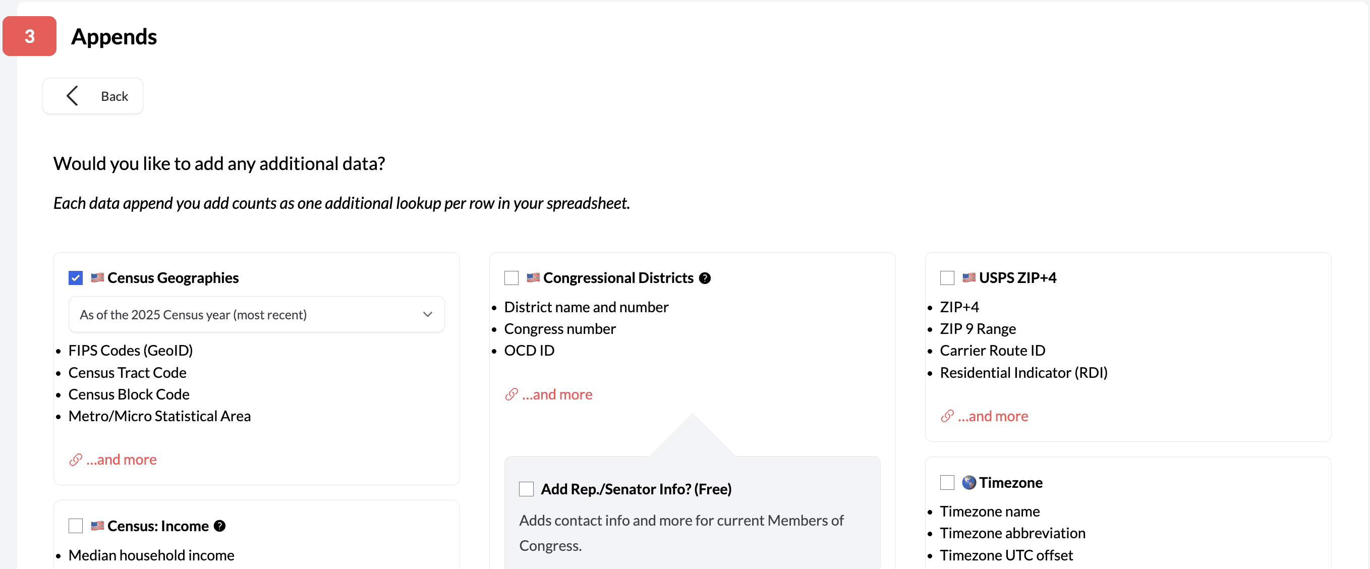
Adding Census 2025 data to a spreadsheet of addresses or coordinates
Prefer working with spreadsheets? Geocodio can help!
With Geocodio, you can upload a spreadsheet of addresses and one-click add Census geographies. When you upload your file and check the box for "Census Geographies" in the Data Appends step, you'll now see an option to select "As of the 2025 Census year (most recent)" from the dropdown menu.
Choose that option and you're all set. (Remember, if you don't select an option from the drop-down, it will default to the Census 2025 geography.)
What about the latest Census American Community Survey (ACS) data?
The 5-year Census American Community Survey (ACS) is where Geocodio sources its Census demographic, household income, education and veteran status, housing status, and family statistics data.
Due to the government shutdown, the Census Bureau has delayed the release of the 2024 ACS data from December to January 29, 2026.
Geocodio will add the latest ACS data as quickly as possible once it is released.
With Geocodio, you'll always get human support
If you have any questions about accessing the latest Census data or anything else related to data appends, please don't hesitate to reach out to our support team. You'll always reach a friendly, knowledgeable human who will be able to help with your question. We're here to help!