
Updates
on everything Geocodio
Geocodio 2025 Year in Review: Faster Geocoding, Richer Data, Easier Integrations
It’s been an exciting year of development at Geocodio!

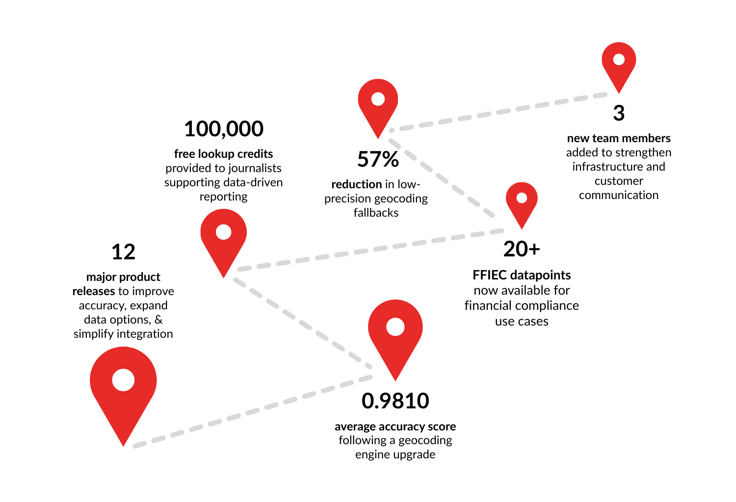
2025 marked Geocodio's most significant year of product development since launching in 2014. Geocodio delivered 12 major releases focused on three core areas of its geocoding service: improved accuracy, expanded data enrichment options, and simplified developer integrations.
Key highlights:
Core geocoding engine upgrade achieving 5% faster processing, 0.9810 average accuracy score, and 57% fewer low-precision fallbacks
Expanded Census ACS data with flexible geography-level selection
Google Maps API compatibility mode enabling seamless migration with identical request parameters
New Python library simplifying integration for developers and data scientists
100,000 free geocoding credits for journalists supporting data-driven reporting
These improvements reflect Geocodio's commitment to making location data accessible, accurate, and straightforward for anyone working with addresses, coordinates, and related data in North America.
In this review:
Making Geocoding Faster, More Accurate, and Secure
Fundamental geocoding engine upgrade
In November, Geocodio completed a comprehensive upgrade to its core proprietary geocoding engine—the most substantial update to the underlying technology since 2015. This infrastructural improvement marked a fundamental reimagining of how addresses get matched to coordinates.
What improved:
Average accuracy score: increased to 0.9810 (on a scale where 1.0 represents perfect rooftop accuracy)
Low-precision fallbacks: decreased by 57%, meaning far fewer addresses returned broad ZIP code-level matches when address-level precision was available
Processing speed: 5% throughput improvement for both forward geocoding (address to coordinates) and reverse geocoding (coordinates to address)
The value for your work
Higher accuracy means more reliable location data for applications ranging from emergency response routing to demographic analysis. The reduction in low-precision fallbacks is particularly significant for organizations that need precise coordinates—an address-level match provides more actionable location data.
For the many organizations who use Geocodio as the first stop in a waterfall of geocoders, this means reduced geocoding costs. Organizations using Geocodio's dedicated instances can see immediate benefits from these improvements with no configuration changes required.
Continued enterprise-grade security verification
Geocodio's Enterprise product successfully completed its latest SOC 2 Type II audit in May. SOC 2 is an auditing standard developed by the American Institute of CPAs that evaluates how well a service provider manages customer data based on five trust principles: security, availability, processing integrity, confidentiality, and privacy.
A Type II audit specifically examines whether security controls operate effectively over time, not just whether they exist in a compliance document. Third-party auditors tested the Geocodio Enterprise infrastructure and operational processes over several months to verify data protection practices.
This verification enables Geocodio to continue serving customers who must meet strict data security requirements, such as finance, healthcare, and Fortune 500 companies.
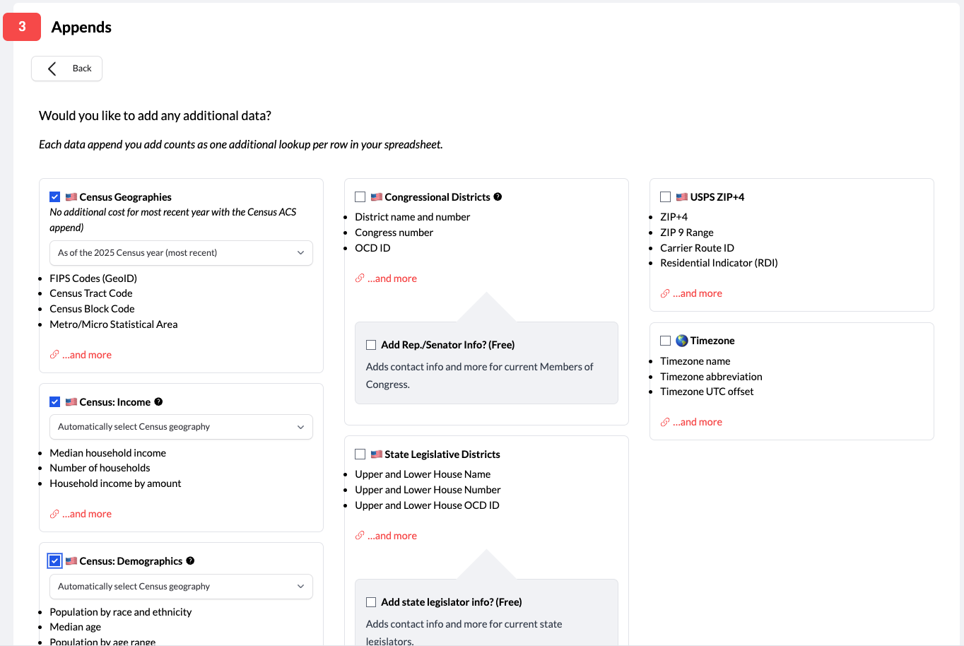
Enhanced Location Data Enrichment
More current, more flexible Census data
Geocodio updated Census American Community Survey (ACS) appends in May to use the latest five-year estimates (2023), replacing 2021 data. The ACS provides detailed demographic, economic, housing, and social characteristics for geographic areas across the United States.
The update included:
New ACS data tables covering:
Per-capita income (past 12 months)
Average household size
Family type by presence and age of own children
Own children under 18 years by family type and age
Geographic-level flexibility:
Previous versions returned ACS data at Census Block Group level by default
The updated API now adapts based on geocoding accuracy or accepts explicit geography requests (tract, block group, or block level).
Geocodio also added geography-level selection for people geocoding spreadsheets. Users can now select their preferred geography level for ACS data directly in the upload interface, making batch processing more flexible without requiring API integration.
Whether you're a retailer looking at site selection for new locations or a healthcare researcher working on social determinants of health, these updates mean you can spend more time on the work that matters and less time manually wrangling Census data.
Get the exact Census data you need, at the geography level your project requires. You can just send an address to Geocodio, tell us what you want, and we'll take care of the rest.
And as of this month, Geocodio's Census data append returns the most recent geographies released in 2025.
The census data append will now default to the 2025 dataset
The 2025 dataset can also be accessed explicitly via census2025
Geocodio can append various US Census-designated geographies to an address or coordinate pair, including:
Census Tract
Census Block
FIPS codes
MSAs (Metropolitan/Micropolitan Statistical Area) /CSAs (Combined Statistical Area), and more
All geographies back to 2000 still available
Learn how to use the Census append here.
Tract-level income data for the financial industry
In March, Geocodio launched support for a FFIEC data append. This data append provides over 20 commonly used datapoints from the FFIEC (Federal Financial Institutions Examination Council) flat file, designed for financial institutions, lenders, and organizations that need to comply with fair lending regulations.
The FFIEC data helps financial institutions determine whether an address lies in a low-to-moderate income Census tracts, which is required to show Community Reinvestment Act (CRA) compliance.
People have told us for years that existing tools and processes for CRA and ECOA (Equal Credit Opportunity Act) compliance can be complicated, expensive, and clunky, and now compliance teams can simply upload a spreadsheet and get all of the data they need in one simple, affordable request.
Updated legislative information and district boundaries
Geocodio expanded political geography data throughout 2025 to keep pace with redistricting changes and provide more detailed legislator information.
Journalists, researchers and organizations conducting constituent outreach, managing advocacy campaigns, or analyzing political geography need accurate, current district information.
As states like Texas and California proceed with mid-cycle redistricting efforts, keeping district boundaries up-to-date ensures addresses get matched to the correct representatives and new districts are accessible for the upcoming 2026 midterm elections. Geocodio's comprehensive legislator contact information makes it easy to go from district identification to action.
Congress member photos (June)
As part of an upgraded Congressional district append, if the current Congress (i.e. cd or cd119) is specified, Geocodio will also now return a photo_url in the detailed information about the current legislators.
State legislator data (June)
A newly upgraded stateleg append returns comprehensive information about state legislators representing a given address, including:
Full name and party affiliation
Contact information (office phone, email where available)
Official website and social media links
Photo URL
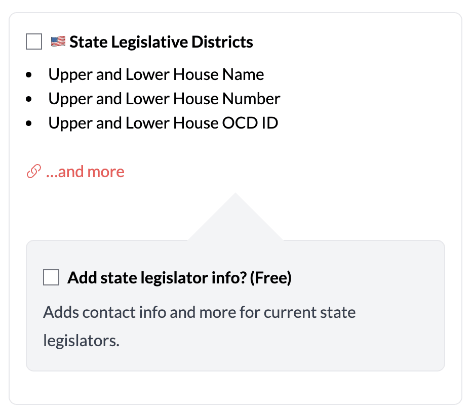
This data is accessible via API or spreadsheet upload, making it straightforward to match addresses to their state representatives for constituent outreach, lobbying campaigns, or civic engagement projects.
District naming standardization (June)
This change revised district naming conventions across all 50 states to match local and state-specific naming patterns.
Previously, Geocodio used inconsistent naming, inherited from state datasets, that could cause mismatches when joining with other datasets. The standardized naming reduces errors in automated data pipelines and makes it easier to cross-reference with other political data sources. Geocodio still provides the state-specific names while also providing standardized names.
120th Congress district boundaries (November)
Geocodio also added support for Congressional District boundaries for the 120th Congress (convening January 2027) through a new cd120 append.
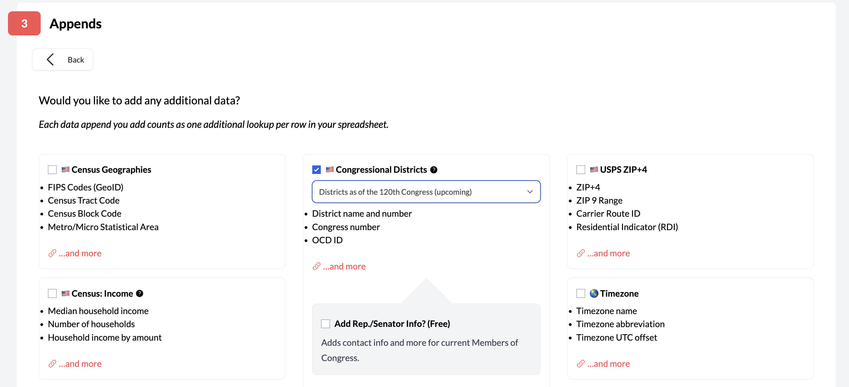
This allows organizations to map addresses or coordinates to their correct upcoming districts even as mid-cycle redistricting occurs. As impacted states update their congressional district maps in the coming months, new boundaries will be added to this append, ensuring that you're prepared for the 2026 US election.
Redistricting tracker improvements
In September, Geocodio streamlined its Redistricting Tracker with improved clarity around which states have completed redistricting for congressional and state legislative districts. Following the 2020 Census, states redrew district boundaries in a multi-year process with states completing redistricting at different times.
The improved tracker uses color coding to show which states:
Have finalized new district boundaries (included in Geocodio's data)
Have pending changes (approved but not yet implemented in the API)
Are still in the redistricting process
The practical impact
Organizations working with political data need to know whether they're using pre- or post-redistricting boundaries. Matching addresses to outdated district boundaries produces incorrect legislator matches and flawed political analysis.
The Redistricting Tracker provides transparency about data updates, allowing users to determine whether Geocodio's current district data meets their needs or whether they should wait for pending updates. This is particularly important for political campaigns, advocacy organizations, and news outlets covering elections.
Updated Canadian electoral districts
In January, Geocodio added support for Canadian federal and provincial electoral ridings for 2025 elections. This data is available through both API and spreadsheet upload for addresses in Canada.
Organizations working with Canadian address data—whether for political campaigns, demographic analysis, or civic engagement—can access the same straightforward geocoding and data enrichment workflow they use for U.S. addresses.
Discover all Geocodio data appends.
Developer-Friendly Geocoding
As a geocoding service co-founded by a developer, Geocodio keeps developer experience at the core of its prioritization and API design. Making life easier for developers is something that drives us, and we launched two major projects that make it easier for developers to integrate geocoding into their apps.
Official Python library
In August, Geocodio released an official Python library that simplifies geocoding integration for developers, data scientists, and anyone writing automation scripts. Python is particularly popular with research and analytics use cases.
pip install geocodio-library-pythonThe Geocodio Python library handles common geocoding tasks with minimal code:
Forward geocoding (address to coordinates)
Reverse geocoding (coordinates to address)
Batch lookups processing multiple addresses efficiently
Data appends (Census, legislative districts, timezone, etc.)
Automatic response parsing
Built-in error handling
The value for your work
Before this library, Python developers had to write boilerplate code for API requests, handle pagination for batch operations, parse JSON responses, and implement error handling.
The official library eliminates this repetitive work, allowing developers to focus on their actual analysis or application logic. For data scientists working in Jupyter notebooks or building ETL pipelines, this reduces integration time from hours to minutes.
Google Maps API compatibility mode
In early December, Geocodio launched a Google Maps API drop-in compatibility mode that accepts Google Maps Geocoding API request parameters and outputs responses in the same format. This means developers can switch from Google Maps to Geocodio by simply changing the endpoint URL (host & API key)—minimal code changes required.
The compatibility mode supports standard Google Maps geocoding API features including:
Address geocoding with identical parameter names
Reverse geocoding (lat/lng parameter)
Component filtering (country, postal code, etc.)
Response format matching Google's JSON structure
Batch geocoding capabilities
Cost savings
Google Maps Geocoding API costs $5.00 per 1,000 requests (after the first 10,000 requests per month). Geocodio's pay-as-you-go pricing starts at $1.00 per 1,000 lookups ($0.50 per 1,000 until February 1, 2026) with volume discounts beginning at 500,000 lookups.
Additionally, customers are allowed to store the data they get from Geocodio, while storing geocodes is prohibited by Google. Geocodio's lower pricing combined with the ability to store geocoded results means that organizations can realize substantial cost savings by switching to Geocodio—often 80-90% reduction in geocoding expenses.
Migrating between geocoding services typically requires significant development work—rewriting API calls, restructuring code to handle different response formats, and testing extensively. Now, organizations can test Geocodio with their existing codebase, compare results, and migrate production systems with minimal engineering time.
Mapping and Visualizing Data More Effectively
Heatmap visualization
In January, Geocodio added heatmap overlay capabilities to the Maps tool.
The heatmap view complements marker-based visualization rather than replacing it—users can toggle between views depending on the questions they're trying to answer.
Heatmaps show density patterns by displaying concentration gradients—areas with many addresses appear in warmer colors (red, orange) while sparse areas appear cooler (blue, green). This makes it immediately obvious where activity clusters occur.
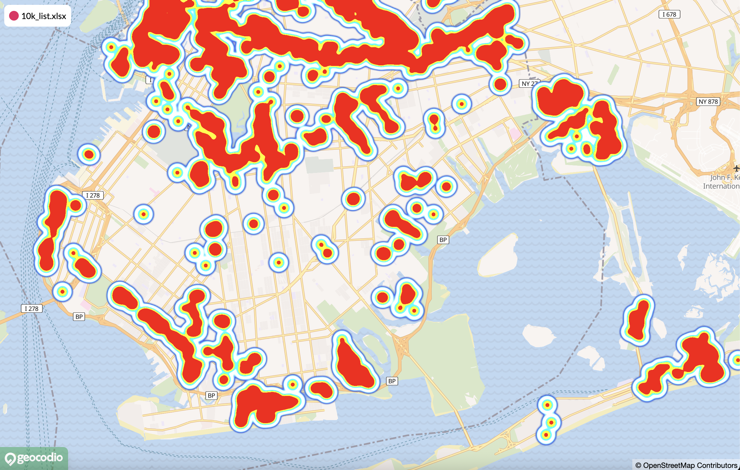
Heatmaps can reveal patterns:
A retail business analyzing customer locations can instantly identify neighborhoods with high customer density for potential new store locations.
Emergency management teams can visualize incident concentrations to optimize resource deployment.
Researchers studying disease outbreaks can spot geographic clustering patterns.
Making a map with FFIEC tract income levels
The FFIEC Income Indicator layer added to Geocodio Maps in April provides a visual representation of Census tract income levels based on FFIEC classifications. Census tracts are color-coded to show their qualification under FFIEC flat file definitions.
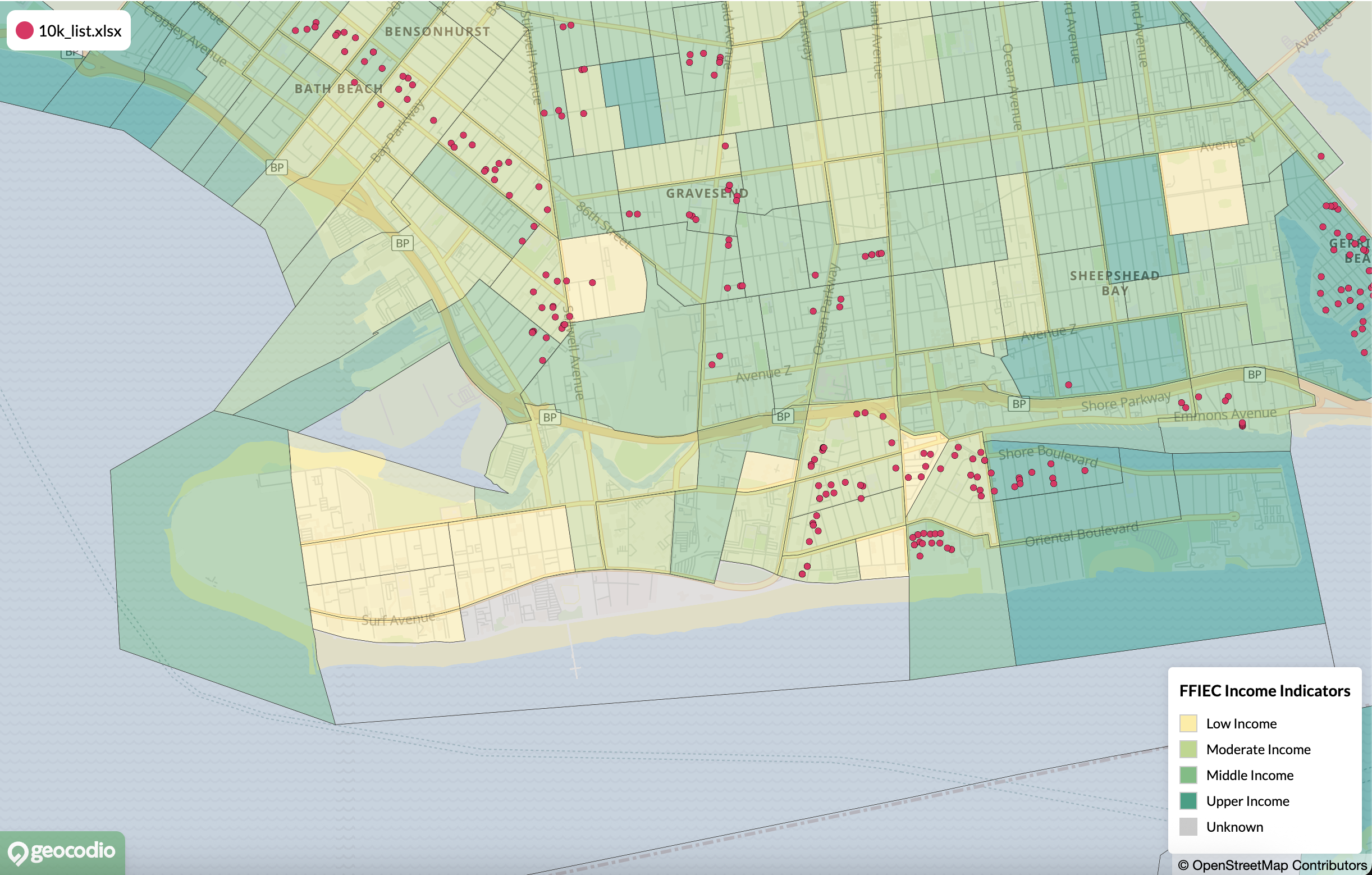
Financial institutions and community development organizations can quickly assess the income characteristics of Census tracts without processing individual addresses.
This visual layer streamlines site selection for community investment projects, helps identify CRA-qualifying service areas, and supports fair lending analysis. The visual format makes it easier to explain geographic patterns to stakeholders who may not be familiar with detailed demographic data.
Supporting Public Interest Work
Free geocoding credits for data journalists
In July, Geocodio announced a program providing 100,000 free geocoding credits to journalists. This initiative supports data-driven reporting and public-interest journalism by making location data accessible to newsrooms and individual reporters.
Qualifying journalists receive credits that can be used for:
Mapping incident reports or public records
Analyzing geographic patterns in news data
Enriching datasets with demographic context
Creating data visualizations for stories
Context for this update
Many newsrooms and independent journalists often lack the budget for commercial data tools, yet increasingly need geocoding and demographic data to tell important stories. This program removes financial barriers to data-driven reporting.
This initiative continues Geocodio's longstanding contributions to the public interest. In 2021, Geocodio published the entire Paycheck Protection Program loan dataset with geocodes and Census geographies for free (still available here). This data was later used in reporting by the San Francisco Chronicle, Reveal, and other news organizations.
Geocodio 2025 in Numbers
Looking Ahead to 2026
Pricing updates
To continue improving geocoding accuracy, expanding data coverage and usability, and maintaining reliable infrastructure, Geocodio will adjust pricing for Pay-as-You-Go, Self-Service Unlimited, and Enterprise Unlimited plans effective February 1, 2026.
These changes enable continued investment in the accuracy improvements, data appends, and developer tools delivered throughout 2025. The updates reflect increased costs for underlying data sources, infrastructure scaling to handle growing usage, and ongoing development of new features.
Geocodio remains committed to transparent, straightforward pricing that lets organizations of all sizes access high-quality location data. Detailed pricing information and specific rate changes are outlined in this update.
Team growth
We were thrilled to welcome three new team members in 2025. These additions reflect Geocodio's investment in both technical excellence and customer experience as the service continues growing.
October: Sylvester Damgaard joined Geocodio from Laravel as Principal Software Engineer, Infrastructure, bringing deep expertise in cloud infrastructure and systems reliability. This addition strengthens Geocodio's ability to maintain high availability and optimize performance as usage scales. Emily Backe joined as Executive Assistant, contributing in multiple areas across the business.
November: You may have noticed this is the first year-in-review post we've ever done. That's one of the initiatives of our new (and first!) Marketing Manager, Kimberlee Keene. Her role is focused on making sure people understand the powerful, time-saving things they can do with Geocodio.
Thank You for Another Year
Geocodio's 2025 improvements in accuracy, data richness, and developer experience set the foundation for continued growth in 2026.
Since its founding in 2014, one of Geocodio's guiding principles has been to ensure our service lets you get in, get out, and get on with your work. We prioritize ease of use and promote a hassle-free experience that doesn't involve restrictions on how you use the location data you get from Geocodio.
This year's enhancements reflect Geocodio's core commitment: making geocoding and location data enrichment straightforward, affordable, and reliable for developers, data analysts, and organizations of all sizes.
Thanks for letting Geocodio be part of the amazing, data-driven work you've done in 2025—and for sharing what you need to keep things running smoothly. Here's to what we'll build together in 2026!
Questions about any of these updates? The Geocodio team is available to help—write us anytime at [email protected] or visit our Updates.
Related
2025 Geocoding Engine Upgrade
Geocodio has recently deployed a major update to the Geocodio geocoding engine.
Geocodio’s Redistricting Tracker
Geocodio tracks redistricting and updates boundaries as new or revised districts are released.
Don't miss what's new
Geocodio ships new features and data updates regularly. We'll only email you with the good stuff, nothing else.
Thanks for subscribing! Check your inbox to confirm.